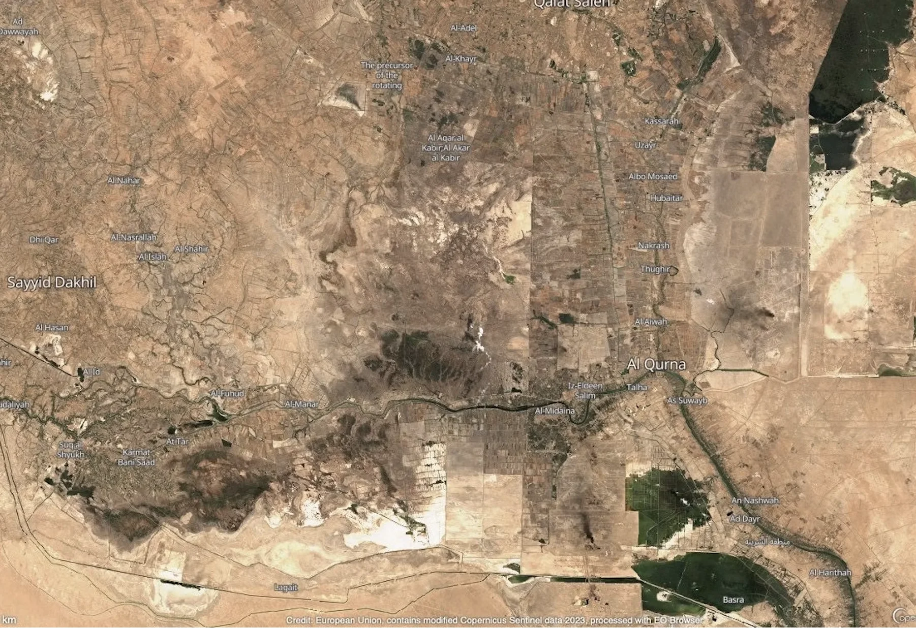
Water resources in Iraq face critical challenges that threaten their sustainability and have a profound impact on the livelihoods of the population and the environment. In the past four years, the country has experienced a deeply concerning decline in water sources and a noticeable degradation in water quality, which have affected the viability of agriculture in certain areas. Iraq is at the epicenter of a global drought crisis. It ranks as the world’s fifth-most vulnerable country, in terms of climate change. It is losing an estimated 8–12 billion cubic meters of surface water annually due to evaporation. And even as increasing heat turns Iraq’s water into vapor, less water is pouring in: the flows of the Tigris and Euphrates are diminishing because of neighboring countries’ policies and their development projects on these rivers and their tributaries. Further, internal water mismanagement—including unregistered agricultural projects and fish farms—exacerbates the situation. This mismanagement is overseen by individuals who lack authorization for their work from relevant ministries, such as the Ministry of Agriculture, the Ministry of Environment, and the Ministry of Water Resources. The human costs of Iraq’s water crisis are clear enough, ranging from polluted water that has sickened thousands to abandoned farms, mass migration, and destroyed ecosystems. Here, I present a different and important perspective: a view from earth’s orbit. Satellite images reveal the staggering degradation and disappearance of Iraq’s water resources—as well as some facts about the causes of the crisis.
Strategic Reservoirs and Natural Lakes
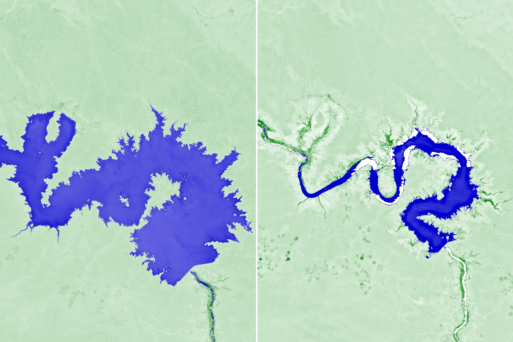
Lakes and reservoirs formed by dams play a crucial role as vital water sources in Iraq. They also serve as significant indicators of fluctuating water conditions, providing insights into the country’s strategic water reserves. Over the past four years, there has been a noticeable decline in water levels across most of these strategic lakes and reservoirs. This decline can be attributed to reduced water inflows, the impact of climate change, and the depletion of lake waters resulting from human activities, including the creation of artificial lakes. Examples of such lakes include Hamrin, along with natural ones like al-Habbaniyah in Anbar governorate, al-Razzaza (the second-largest lake in Iraq, spanning Karbala and Anbar), Sawa in Muthanna, al-Tharthar in the northwest of Tikrit governorate and northern Anbar, and Dukan in Iraqi Kurdistan. The images captured by the Sentinel Hub satellites, utilizing the Normalized Difference Water Index (NDWI) for water spot monitoring, reveal a significant decrease in the water levels of Lake Qadisiyah, a man-made body on the Euphrates in Anbar. With a surface area of five hundred square kilometers and a storage capacity of 8.2 billion cubic meters, this lake holds strategic importance as the key reservoir for the Haditha Dam. Lake Qadisiyah is recognized as the fourth-largest lake in Iraq. However, the lake is currently grappling with a severe reduction in water inflows.
Iraq has experienced notable climatic changes, including a significant reduction in rainfall. Coupled with escalating evaporation rates, these factors have had a profound impact on the natural landscape. Satellite images have revealed the alarming disappearance of Sawa Lake in Muthanna governorate. Sawa Lake is a naturally occurring body of about twelve square kilometers that is fed by an underground aquifer connected to the Euphrates. Despite previous reports of the governorate’s efforts to restore water to the lake in May 2022, recent photographs circulated in Iraqi and international media indicate that the lake has almost completely vanished. This serves as a stark illustration of the severity of the water crisis and its detrimental effects on the region’s ecosystems.
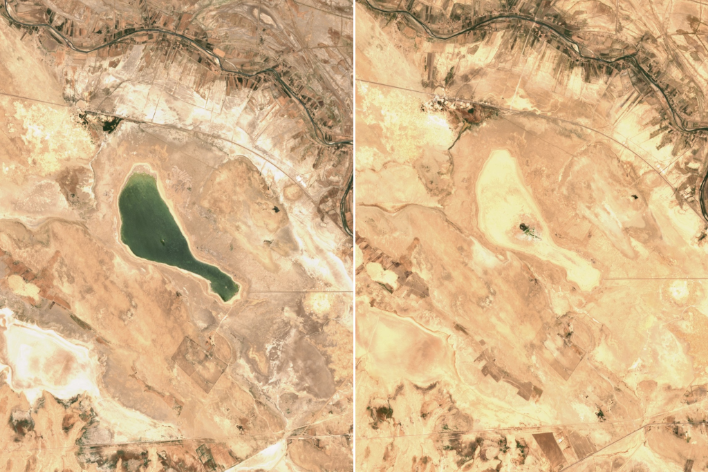
Sawa Lake heavily relies on groundwater as its primary source of replenishment. Unfortunately, this groundwater supply has also experienced a decline due to various factors, including insufficient rainfall, disruptions caused by climate change, and the unregulated digging of artesian wells. The demand for these wells has intensified as the water crisis has worsened. Consequently, the combination of reduced rainfall, climate disturbances, and uncontrolled well excavation has exacerbated the overall scarcity of water, leading to the depletion of groundwater. The condition of Sawa Lake shows the interconnectedness of the issues contributing to the water crisis—and, relatedly, the need for comprehensive measures to address the water crisis and regulate the utilization of groundwater resources.
Marshes on the Brink
The famous marshes of the Tigris and Euphrates floodplains also face significant environmental challenges, primarily related to drought and climate change.
Saddam Hussein’s regime systematically drained the marshes, but they were partially restored to life in 2006. In 2016, UNESCO recognized the marshes, which host an ancient culture and unique biodiversity, as a World Heritage site.
Yet the marshes have been pushed back to the brink due to severe drought conditions. Upstream desertification, lower inflows, and climate change have all made the effects of the drought worse, and strained the marshes’ ecosystem.
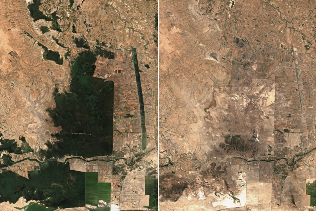
Satellite images provide clear evidence of the diminishing green areas within the marshlands over the past four years, with a corresponding increase in barren areas. This visible transformation highlights the ecological consequences of prolonged water scarcity and changing climatic patterns.
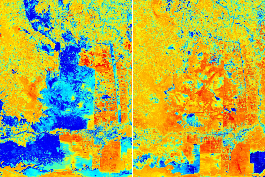
Processing satellite images with the Normalized Difference Moisture Index (NDMI), which shows vegetation and water content, effectively identifies a decline in humidity levels and an escalation in dryness within the marshes. The wet areas are visually represented by vibrant blue hues, while the dry regions are depicted through distinct yellow-red shades.
A Human-Caused Crisis
Human activities have played a detrimental role in the destruction of Iraq’s lakes.
Alongside the aforementioned factors contributing to their decline, the consequences of human actions have had severe implications. Examples include the reduced release of water from dams in Iran, which has cut off forty tributaries of the Euphrates, and the construction of dams by Turkey along the Iraqi border, which have also significantly diminished water resources.
Hamrin Lake, a 340-square-kilometer man-made reservoir in Diyala governorate, stands out as having suffered from these factors. The lake has experienced an 80 percent reduction in its water level, according to Thaer Obaid, a professor of air and environmental sciences at Al-Mustansiriya University. In interviews, Obaid has explained this decrease as a result of the scarcity of water from the Alwand River in Iran, and from the Darbandikhan Dam in Iraqi Kurdistan, which heavily relies on the Alwand River for sustenance. Furthermore, agricultural and industrial activities have contributed significantly to the decline of available water. For example, Razzaza Lake—a 1,500-square-kilometer reservoir constructed in the 1970s—has dried up due to the depletion of nearby groundwater caused by the drilling of approximately 1,000 artesian wells for agricultural purposes in Karbala governorate, as reported by the Ministry of Water Resources.
The situation has been exacerbated by the proliferation of artificial fishponds, which have doubled in number in recent years.
The situation has been exacerbated by the proliferation of artificial fishponds, which have doubled in number in recent years. According to a report from the Office of Financial Supervision for the year 2018, the number of unauthorized lakes in Iraq surged from 680 to 1,970 between 2014 and 2017, and this figure has further doubled in recent years. In Karbala governorate, specifically, the operation of artificial fishponds witnessed a significant rise, with more than 160 lakes recorded in 2016, up from just 30 in 2014. These ponds varied in size, ranging from five hundred square meters all the way up to eighteen square kilometers. Further, satellite imagery and the NDWI have revealed a noticeable growth in the size and number of these artificial fishponds. In particular, the lakes associated with the Abbasid Shrine projects in Karbala, located near Razzaza Lake, have exhibited substantial growth. These ponds heavily rely on the water resources of Razzaza Lake to sustain their operations and support the artificial fish populations.